Wrotham, Kent, England
Ford
Place
Elizabeth Culpeper, daughter of Walter Culpeper9w
of Calais and Wigsell, was born in Ford Hall circa 1493.
According
to notes made by Culpeper historian Len Pierce and provided to
Warren Culpepper, the family of
Clerke (Arms: Argent, a bend
engrailed azure, a cinque fiul pisined or), sold Ford Place to Mr.
John Know, 1725 (Argent, a bend engrailed gules, three
trefoils, slipt of the first.). Mr. Pierce noted the similarity between
the arms of Clerke, Know and Culpeper (Argent,
a bend engrailed, gules).
Location: About 2 miles E of Wrotham, on Ford Lane, off the
A20, just south of the M26/M20 split.
National Grid Coordinates:
TQ
637 587 |
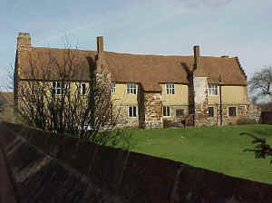
Ford Place, March 2000
Photo taken by Warren Culpepper
|
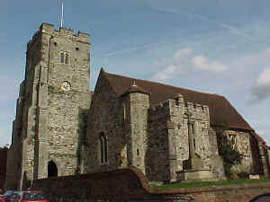 St.
George Church St.
George Church
Ancient Parish in Wrotham
Original registers
from 1558.
Connection, if any to Culpepers, not currently known. Further
research needed.
National Grid Coordinates:
TQ
612 592
Photo taken by Warren Culpepper in
March 2000. |
Wrotham, Kent
Location: Between the M26 and the M20, 16
miles NW of Goudhurst, and 11 miles WNW of Maidstone.
National Grid Coordinates: TQ
610 590
Seemingly oblivious to the M20 which passes just
to the north is Wrotham (pronounced Rootum), an ancient village
which once served as a staging post on the London road. It was
here that Henry VIII received news of the execution of Anne Boleyn
in 1536. Wrotham parish church of St George would have been more
than three centuries old at the time. It is large and airy,
perhaps because the village once had a palace belonging to the
Archbishops of Canterbury. The heart of Wrotham, next to the
church, is its compact village square which has two very old pubs,
a brick manor house and the remains of the archbishop's palace.
Source: Sean Connolly, Ed.,"Wrotham", The Hidden
Places of Kent, Travel Publishing, Ltd., 1998., pages 16-17. |
|
1831 Topographical Dictionary:
WROTHAM, a parish (formerly a market town) in the hundred of
WROTHAM, lathe of AYLESFORD, county of KENT, 11 miles WNW from
Maidstone, and 24 miles ESE from London, containing, with
the townships of Hale, Nepicar, Plaxtol, Winfield, and Roughway,
2357 inhabitants. This is a place of very remote antiquity: that
it was a town of the ancient Britons is probable from various
discoveries of British coins, and fragments of brass armor and
military weapons; other circumstances lead to the conclusion that
it was afterwards a Roman station, and the ancient military way
from Oldborough to Stane-street passed through it. The town is
situated near the foot of the chalk hills, and consists
principally of two streets crossing each other on the high road
from London to Maidstone; in the center is the market-place... The
church, dedicated to St. George, is an ancient and spacious
structure, with a mixture of the various styles, from the Norman
to the later English; it contains sixteen stalls. A palace for the
Archbishops of Canterbury formerly stood here, of which the
terrace and a few offices alone remain. Wrotham hill, immediately
above the town, affords one of the finest prospects in England.
|
Also See: Old Soar, Oxen Hoath, Dukes
Place, Hadlow
and West Peckham
Last Revised:
02 Jan 2015 |
|


