Sevenoaks, Kent, England
Manors and Lands of the Culpepers
 Brook Place at Riverhead in
Sevenoaks Brook Place at Riverhead in
Sevenoaks
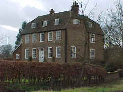
The ancient mansion in Riverhead at Sevenoaks called Brook Place
was built by one of the family of Culpeper out of materials taken from the
neighboring suppressed hospital
of St. John. It after came into the possession of a younger
branch of the family of Amherst. (Hasted Volume III, pages 92-93)
Culpepper Connections Note: The specific Culpeper who built the
house is unknown, but he may have been of the Bedgebury line and
probably built it in the 16th century.
Location: On Norman Road, 0.5 mile W of the B-2042, 3
miles SW of Riverhead
National Grid Coordinates: TQ 491 529
Photograph by Warren Culpepper, March 2000.

Britains in Sevenoaks (Including Great
Britain's Wood)
In the reign of Edward VI, the
house and lands of Britains in Sevenoaks were leased by the
Earl of Warwick for 40 years to Sir George Harper and Thomas
Culpeper10b, Esq. (Hasted Volume III, page 90)
Sir George Harper and Thomas Culpeper, were
half-brothers, the sons of Constantia Chamberlayn, who married
first, Sir Alexander Culpeper9b of Bedgebury and Hardreshull, and
second, Richard Harper.
In March 2000, no home named Britains could be located by Culpepper
Connections, but Great Britain's Wood is traversed by the A-21
on the south side of Sevenoaks.
Location: On the A-21, about 2 miles S of where the M-25
changes into the A-21.
National Grid Coordinates: TQ 516 542

Whitley
Forest in Sevenoaks
John, duke of Northumberland, made a lease of Whitley Forest (alias Whitcliff Wood) in Sevenoaks
to Sir George Harper and Thomas Culpeper10b, Esq., who granted their
interest in them to Christopher Roper. (Hasted Volume III, page
70).
Sir George Harper and Thomas Culpeper, were
half-brothers, the sons of Constantia Chamberlayn, who married
first, Sir Alexander Culpeper9b of Bedgebury and Hardreshull, and
second, Richard Harper. Note, also, that Sir Alexander was the
grandson of Walter Culpeper7b and Agnes Roper, and Agnes was the
daughter of Edmund Roper of St. Dunstan's Canterbury. Christopher
Roper, to whom the above lands were granted, was presumably a
member of this Roper family.
Location: On east side of the B-2042, 2 mile S of its
intersection with the A-25.
National Grid Coordinates: TQ 505
530 |
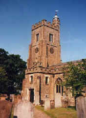
 St.
Nicholas Church St.
Nicholas Church
Ancient Parish
Original registers from 1559
Location: On Tonbridge Road (A-225, just
south of intersection with the A-224.)
National Grid Coordinates: TQ 531 543
More research needed to see if any Culpepers were
involved in this parish. |
Sevenoaks, Kent
Location: On the A-25, just south of the
M-26, 16
miles NW of Goudhurst, and 17 miles W of Maidstone.
National Grid Coordinates: TQ
530 560
With its easy rail and road access to London and
its leafy atmosphere Sevenoaks has come to epitomize the essence
of the commuter belt in many people's eyes. This perception is not
far from the truth but far enough away to reveal a genuine
community with its own sense of history and identity. The
leafiness is not that of a garden city creation, designed to
soften the effect of wide-scale residential and commercial
development. Instead it is a testament to the wooded countryside
which formed the backdrop of this settlement some nine centuries
ago.
It is believed that there was a settlement on this
site in ancient times but the first recorded mention came in AD
1114 when a record of local churches listed it as "Seovenaca".
Local tradition has it that the name refers to a clump of seven
oaks that once stood here, long gone but replaced - with much
fanfare - by seven trees taken from Knole Park and ceremoniously
planted on the common on the outskirts of town in 1955. These
replacements gained national headline status in 1987, when they
suffered badly during the Great Wind of October.
The rural feel of Sevenoaks - struggling against
the odds - parallels the story of those trees. Despite the
commuter tag which it must bear, Sevenoaks still has the
appearance of a country market town, and it holds weekly cattle
and produce markets not far from the station. A number of
traditional Kentish tile-hung cottages, as well as a fine Regency
pub and some grand houses, still line the main street before it
assumes a more anonymous aspect.
Not far from the center of Sevenoaks, however, are
further reminders of the town's heritage. The Vine cricket ground
lies on a rise to the south of the town center. It was given to
the town in 1773 but the first recorded match at the Vine between
Kent and Sussex - took place in 1734. It witnessed a remarkable
match in 1782 when the Duke of Dorset (one of the Sackvilles of
Knole) and his estate workers defeated a team representing
All-England. The victory was particularly sweet because the Duke's
team also won a bet of a thousand guineas.
The pride of Sevenoaks, and of Kent itself for
many people, is of course Knole House, the huge manor house
set in extensive parkland. It is one of the largest houses in
England, with 365 rooms inside its foursquare structure.
 The
present house stands on the site of a much smaller manor house
which was bought by the Archbishop of Canterbury in 1456 and used
as an ecclesiastical palace until 1532 when it was taken over by
Henry VIII. Elizabeth I granted it to the Sackvilles, who still
live there although the house is now owned by the National Trust.
Impressive in its scale, Knole House also offers visitors the
chance to wander past outstanding collections of tapestries,
antique furniture and an extensive art collection which has
masterpiece by Gainsborough and Reynolds. The
present house stands on the site of a much smaller manor house
which was bought by the Archbishop of Canterbury in 1456 and used
as an ecclesiastical palace until 1532 when it was taken over by
Henry VIII. Elizabeth I granted it to the Sackvilles, who still
live there although the house is now owned by the National Trust.
Impressive in its scale, Knole House also offers visitors the
chance to wander past outstanding collections of tapestries,
antique furniture and an extensive art collection which has
masterpiece by Gainsborough and Reynolds.
The great house is not without its sense of human
involvement. The Sackvilles proved to have the flair for employing
the best craftsmen to realize their creative architectural spirit.
The writer Vita Sackville-West was born in Knole House in 1892;
some five decades later Hitler intended to use it as his English
headquarters.
Surrounding Knole House is its majestic deer park,
covering some 1000 acres of rolling countryside with dense beech
woodlands giving way to hidden dells.
Source: Sean Connolly, Ed., The
Hidden Places of Kent, Travel Publishing, Ltd., 1998., page
30-32. |
1831 Topographical Dictionary
Sevenoaks, a market town and parish in the hundred of Codsheath,
lathe of Sutton at Hone, county of Kent, containing, with the
chapelry of Riverhead, and the liberty of Weald, 3942 inhabitants,
of which number, 2114 are in the town, 17½ miles W from
Maidstone, and 24 miles SSE from London. This place, which in
the Textus Roffensis is written Seovan Acca, is supposed to have
derived its name from seven large oaks which stood upon the
eminence on which the town is built: the period of its origin is
uncertain, and the only historical event connected with it is the
defeat and death of Sir Humphry Stafford, by Jack Cade and his
followers, when sent to oppose the rebels by Henry VI, in 1450.
The manor, formerly an appendage to Otford, and as such belonging
to the see of Canterbury, was conveyed, about the time of the
dissolution of the monastic establishments, by Archbishop Cranmer
to Henry VIII, and it subsequently became the property of the
Dukes of Dorset. The town is situated on the ridge of hills which
crosses the county, separating the Upland from the Weald, or
southern part, near the river Darent, in a fertile and beautiful
part of the country. In the reign of
Queen Elizabeth the assizes were held in the ancient market-house,
near the middle of the High-street, and also two or three times at
subsequent periods. |
Also See: Old Soar, Oxen Hoath, Dukes
Place, and West
Peckham, Kent
Last Revised:
02 Jan 2015 |
|