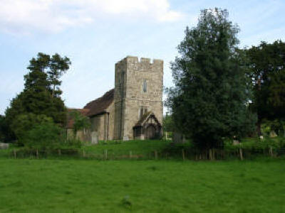
St. Margaret Church, Broomfield (aka Bromfield), co. Kent
Leeds Castle, one of the more important
seats of the Kentish Culpepers in the 17th century, is in the middle
of a triangle formed by Broomfield,
Hollingbourne
and Leeds, and is roughly equidistant from
them.
In the late 18th century, Kentish historian Hasted wrote (History
of Kent, 1793, Volume II, pages 484, 486): |
 |
|
Photograph by Keith Pearce,
© 2003 |
Bromfield was originally a parish, served by a religious of the
priory of Leeds. The boundaries, practically limited to the lands held
of Leeds Castle, have been maintained; but since the dissolution of
the priory the church has been annexed to the rectory and church of
the adjacent Leeds parish which was erected within the priory lands.
As a consequence, Bromfield now ranks as a chapel. Vested by Queen
Elizabeth in the Archbishop of Canterbury, the advowson of Leeds and
Bromfield has since been held by that prelate, who collates a
perpetual curate.
Fairfax Harrison, in his 1926 treatise, The
Proprietors of the Northern Neck, says:
Catherine Culpeper, Lady Fairfax, had all her children baptized
in Bromfield chapel and later built there a family vault where she
buried her mother, and was herself interred, as were a number of her
descendants. The Bromfield register thus became a genealogical source
record for the last generation of the proprietors of the Northern
Neck. For these considerations the Virginia Assembly gave the name
Bromfield to the parish created in Culpeper (VA) in 1752 (Hening, Vi,
256)
St. Margaret's Grid Coordinates:
TQ 840 525 |
Broomfield, Kent
1831 Topographical Dictionary
Broomfield, a parish in the hundred of Eyhorne, lathe of
Aylesford, county of Kent, 6 miles ESE from Maidstone, containing
115 inhabitants... The church is dedicated to St. Margaret. On the
southern side of the parish extends a tract of woodland, called
King's Wood, and within its limits there is a rabbit-warren.
Location: 6 miles ESE of Maidstone and 12
miles NE of Goudhurst. On Broomfield Road, .5 miles S of the A-20 and
1 mile SW of Exit 8 of
the M-20
National Grid Coordinates:
TQ
840 525
|
Also See
Last Revised:
02 Jan 2015
|
|