Tenterden, Kent, England
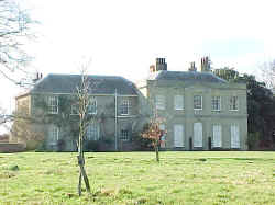
Heronden Manor
There are three different references in ancient
wills to Culpeper holdings called Heronden (Hernden, Heryngden and
Harrenden).
 |
Sir
Thomas Culpeper6 will of 1428: "Touching
the manor of Wyggesell and lands in Hernden in
Sandherst and Newynden because Wyggesell was settled on me and
my wife Joyce and our heirs on our marriage "p chartr
endente," notwithstanding I have made anothor feoffment,
I wish the original gift to stand good." |
|

Heronden Manor, March 2000
Photograph taken by Warren Culpepper |
In 2000, there were four different locations,
all close together, with Heronden in their name. They all lie
within a triangle formed by the towns of Sandhurst, Newenden
and Tenterden.
Location: Off Smallhythe
Road (B-2082), 0.5 mile south of Tenterden.
National Grid
Coordinates:
TQ
882 327 |
Morghew
and Godden Manors
The manors of Morgue (Morghew) and Godden came into the
possession of
Sir John, later Lord Culpeper13w, of Hollingbourne. When he died in 1660; they
passed to his second son John (who subsequently became 3rd Lord
Culpeper14w upon the death of his brother Thomas). John died without
children in 1719, and the manors passed to his wife Frances, daughter of Sir
Thomas Culpeper of Hollingbourne. By will, Frances devised them to
her nephew, John Spence Culpeper, Esq. of Charterhouse. These
were the last
of the vast possessions of the different branches of this family,
and John sold them 1781 to Mr. Richard Curtis.
References to Godden and Morghew (Morghue) may be seen in John
Lord Culpeper's will of 1660.
|

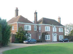
Morghew Manor, March 2000
Photograph taken by Warren Culpepper
|
Source: Hasted, History of Kent, Vol. VII,
pages 210-211.
 |
Morghew
Location : South of Tenterden, W of the B2082 (Small Hythe
Road)
National Grid Coordinates: TQ 886
322. |
 |
Godden. Location is unknown. Probably no longer stands. |
|
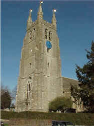
 St.
Mildred Church, Tenterden St.
Mildred Church, Tenterden
Ancient Parish
Registers from 1544.
The Culpepers left no traces in this church.
Photograph taken by Warren Culpepper, March 2000. |
Tenterden
Tenterden is known as the "Jewel of the
Weald"; although it occupies a site that is right in the border
between the dense woodlands of the Weald and the flatter, farming
country that leads eastwards into the Romney Marshes. Today's
well-earned nickname is a far cry from its earliest days, when it was
known as "Tenet-ware-den"; or "pig-pasture of
the men of Thanet"!
Despite the fact that pigs flourished here,
sheep inevitably became the more profitable animal to farm on these
fertile lands, and the wool trade quickly took off. In 1331, the
far-sighted Edward III prohibited the export of unwashed wool and
encouraged weavers
from Flanders to settle here and bring their
dyeing and weaving techniques to the English. The town of Tenterden
and some of its neighboring villages were to become the most important
centers for the manufacture of broadcloth.
Once again, it was thanks to that earlier
reclamation of the Romney Marsh that the area provided excellent
grazing land, and brought about a profitable trade for the Wealden
communities. Just outside Tenterden, Smallhythe and Reading Street
provided access to the sea. These two small ports were founded as a
means of transporting lumber from the Wealden forests, but by the 14th
century, Smallhythe was firmly established as a boat-building center.
The church of St. Mildred can be found in the
heart of Tenterden, and with its unusual twin doors at the western
end, it is lovely. From the top of the 15th century tower -
some 100 feet above the town – are far reaching views across the
Weald to the Channel Coast. Near the church is the Town Hall and the
delightful Woolpack Inn, a proud reminder of the town’s former days
as a cloth trading center. Another inn, the William Caxton, takes its
name from the man who brought printing to England and who is said to
have been born in Tenterden in 1422.
The center of Tenterden stretches along its
broad High Street, lined with shops and houses, nearly all with their
original facades dating from the 16th to 18th centuries. Most of them,
however, were built in a busy period between 1720 and 1760, so there
is something of a Georgian feel to the town as a whole.
Source: Sean Connolly, Hidden Places of Kent,
Travel Publishing Co., 1998, page
118-119.
1831 Topographical Dictionary
Tenterden, a market town and parish
within the cinque-port liberties, having separate jurisdiction,
though locally in the hundred of Tenterden,
lathe of Scray, county of Kent, 18 miles SSE from
Maidstone, and 53 SSE from London, containing 3,259
inhabitants. This place, of which the present name appears to be a
corruption of Theinwarden, or the ward of Thanes, that is, the
guard in the valley, was one of the first places in which the
woollen manufacture was established, in the reign of Edward III.
It became a scene of opposition to the Church of Rome at an early
period, prior to the Reformation, when, in the time of Archbishop
Warham, forty-eight inhabitants of the town and its vicinity were
publicly accused of heresy, and five of them condemned to be
burned. The town stands upon a pleasant eminence, surrounded by
some fine plantations of hops: the houses are well built and of
respectable appearance. The town-hall was built in 1792, the
former having been destroyed by fire, and contains a commodious
room occasionally used for public assemblies. The Royal Military
canal passes within six miles of the town.
Location: 12 miles SSE of Goudhurst and 17 miles SE of
Maidstone. On the A28
National Grid Coordinates:
TQ
885 335 |
Last Revised:
02 Jan 2015
|
|