St. Stephens
Kent, England
St. Stephens Place
In 1527, Archbishop Langton made his brother
Archdeacon of Canterbury and built for him a residence at
Hackington. At the Reformation, it fell into the hands of
the Crown. In 1562, Elizabeth gave it to Sir Roger Manwood,
who rebuilt it. In 1642 Manwood sold it to Col. Thomas Culpeper13b
(afterwards knighted, the fifth son of Anthony Culpeper of
Bedgebury12b) who resided here, died in 1643 and
was buried in the church. In a deed of 1643, it is called St.
Stephens House. It descended to his son Thomas Culpeper14b who had a
wild and curious career. Thomas14b secretly married a daughter of
Lord Frecheville of Stavely in Derbyshire and became
involved in litigation regarding estates of his wife, the
sale of which he opposed. His legal expenses obliged Culpeper to sell his house and estates to Sir John
Hales of Tunstall, in 1675, who pulled the house down and
rebuilt it. The current dwelling is called Hales Place.
National Grid Coordinates:
TR
152 592 |
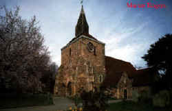
St. Stephen's Church
 The
church is in what was once the village of
Hackington, now formed into part of the general city of
Canterbury. The area is better known these days just as St
Stephen’s, Canterbury. The
church is in what was once the village of
Hackington, now formed into part of the general city of
Canterbury. The area is better known these days just as St
Stephen’s, Canterbury.
The church was built around 1050 AD, with the
tower about a hundred years later and the transepts in the
16th century. The transepts were the work of one Sir Roger
Manwood, a Judge and Chief Baron of the Exchequer in the
reign of Elizabeth I. He founded the grammar school in
Sandwich which bears his name. He was a great benefactor to
the church, resident in the parish, and has an impressive
tomb in the south transept. He and his family members are
all buried within a vault underneath.
Another famous family connected with the parish
include the Hales (from Tunstall). They are not buried at
the church, but gave a clock (still extant). Their burial
place is in a small (Catholic) chapel nearby.
National Grid Coordinates:
TR
148 592 |
St. Stephens (aka Hackington), Canterbury, Kent
Location: On north side of Canterbury,
30 miles NE of Goudhurst and 25 miles E of Maidstone.
National Grid Coordinates (Canterbury): TR
150 580
1831 Topographical Dictionary:
HACKINGTON, otherwise ST. STEPHEN'S, a parish in the hundred
of WESTGATE, lathe of ST. AUGUSTINE, county of KENT, 1¼
mile (N.) from Canterbury, containing 349 inhabitants. The church
is dedicated to St. Stephen. In the church-yard, in 1187,
Baldwin, Archbishop of Canterbury, began a chapel in honour
of St. Stephen and St. Thomas of Canterbury, wherein he
proposed to found a noble college for forty secular priests,
the king and all his suffragan bishops to have a prebend,
each worth forty marks a year; but the year after he had
settled some secular canons at the place, the pope, at the
instance of the monks at Christ Church, ordered the chapel
to be levelled with the ground. The bishop erected a chapel
in honour of St. Thomas à Becket at the foot of St. Thomas'
hill. |
Last Revised:
02 Jan 2015 |
|


