Rolvenden, Kent, England
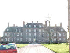 Great Maytham Hall Great Maytham Hall
Helen Hendley, daughter and
co-heir of Walter Hendley of Great Maytham, carried the estate
by marriage to Sir Thomas Culpeper of Bedgebury, the elder10b.
It is mentioned in a settlement made by his grandson, Sir Anthony Culpeper12b
in 1613. It was sold by one of Sir Anthony's descendants in 1714 to James
Moneypenny.
Source: Hasted, History of Kent, Vol. VII,
pages 192-193.
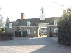 Location: Just south of Rolvenden off the A28. Location: Just south of Rolvenden off the A28.
National Grid Coordinates: TQ 847 308
Photographs by Warren Culpepper, March 2000. Lower
photo is of the entrance gate; the mansion can be seen through it in
the background. |
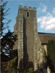 St.
Mary the Virgin Church, Rolvenden St.
Mary the Virgin Church, Rolvenden
The church stands on a low mound at the southern end of
Rolvenden
village. Many parish churches were built on such a mound and there is a
tradition that the first churches were erected on pagan sites in order
to ensure continuity of a place of Worship.
The earliest Anglo-Saxon names of Rolvenden give no clue to the origin
of the church (it means the Denn or pasture of Hropwulf's people). What
is certain is that a church, probably a wooden building, was here at the
time of the Norman Conquest in 1066. Although there is no mention of
Rolvenden church in Domesday Book (the great survey of England ordered
by William the Conqueror in 1086) there is in Domesday Monachorum. This
is a record compiled by order of Archbishop Lanfranc in 1070/71 of the
dues of each church which they paid at Easter to the Archbishop of
Canterbury. From internal evidence it is apparent that these churches
were of Saxon foundation. The entry in the book appears as "De
Ruluindaenne 28d", and amongst other things would have been payment for
the Consecrated oil (Chrism oil) used at Baptisms and for Extreme
Unction for the dying.
What happened to the Saxon church is not known and if a Norman church of
stone replaced it there is no visible evidence of it in the present
building. The earliest surviving part of the church is to be seen in the
chancel and dates from circa 1210. The present structure is mainly 14th
and 15th century and is structurally as it was in 1470.
Source: Tom Page, Kent
County Churches
Photograph: Warren Culpepper, March 2000.
St. Mary's Location: At the intersection of the A28 and B2086, 16 miles
SE of Maidstone and 9 miles SE of Goudhurst.
National Grid Coordinates: TQ
845 312 |
The Culpeper/Guildford Baptismal Font
At the western end of the south aisle of St. Mary the Virgin's
Church in Rolvenden is a hexagonal baptismal font (pictured below)
which dates from the 14th century and is in the "Decorated
Windowed" style. Fonts are uncommon in this shape. It has rather
curious fins at the base. Emblazoned on the bowl are the arms of
Culpeper and Guildford. The wooden cover is 18th century. On two sides
of the bowl may be seen part of the hasps for securing the font cover
with a lock. This was to prevent the water from being stolen by
witches or other people believing it had magic powers. Source:
G. J. Davey, Parish Church of St. Mary the Virgin, Rolvenden: A
Short Guide, 1997, p 11. The Culpeper/Guildford
Connection. Elizabeth Guildford (born circa 1453, probably the
daughter of Sir John Guildford, Knight), married Henry Aucher of
Lossenham. Their daughter, Anne Aucher, married Walter Culpeper9w
of Calais and Wigsell. Anne's 1532 will says:
All my manors and lands in Newenden, Rowynden (Rolvenden) and Biddenden
to certain trustees to hold them to the use of my sone Wyllm and
his heirs.
Given Anne's connection to the Guildford family (through her
mother, Elizabeth), the Culpeper family (through her husband, Walter)
and Rolvenden (as mentioned in her will), it would seem likely that
the Rolvenden baptismal font is connected to this branch of the
Culpeper family. All modern-day Culpeppers are believed to be
descended from Walter and Anne Aucher Culpeper and their son William
Culpeper10w of Hunton and Wigsell.
Photographs: By Warren Culpepper, March 2000. |
|
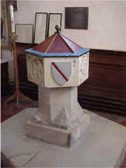
Culpepper Arms on one side of the
Baptismal Font at Rolvenden Church
|
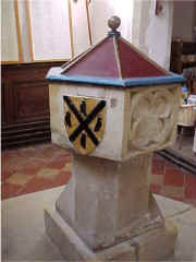
Guildford Arms on other side of the
Baptismal Font at Rolvenden Church
|
Rolvenden
1831 Topographical Dictionary
Rolvenden, a
parish in the hundred of Rolvenden, lathe of Scray, county of
Kent, 2½ miles WSW from Tenterden, containing 1403
inhabitants. The church, dedicated to St. Mary, is principally in
the later style of English architecture. Location:
On the A28 in middle of town.
National Grid Coordinates: TQ
844
315 |
Last Revised:
02 Jan 2015
|
|