Crawley, West Sussex, England
Rowley
Farm at Crawley
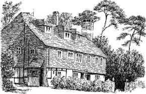
"Rowley Farm, situated between Crawley
Industrial estate and Gatwick Airport, is an early example of a
smoke-bay house. Built in the late 16th century, when the iron
workings were still in full production in the area, it belonged
to the Culpepper family."
(Source of above text and drawing to the right: West Sussex Gazette & S. England
Advertiser, 20 Jan 1983)
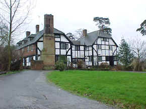
This once peaceful location is still a working
farm that today sits only a few hundred yards south of the
eastern end of the runway of London's busy Gatwick Airport.
Those arriving at Gatwick who are sitting on the left side of
the plane should be able to view it if the approach is from the
east. Or when departing, if the takeoff is to the east, Rowley
Farm can be seen from the right side of the plane. Location:
Immediately south of Gatwick airport. Take the A23 south to
Gatwick Road. 1/4 mile S on Gatwick Road, then 1/4 mile W on
James Watt Way, and turn right on dirt road. House is a few
hundred yards up the dirt road, past some barns.
National Grid Coordinates: TQ
280 396. |

Sketch by Crawley artist Mrs.
Bruce Collins, showing the oldest wing of the house.

Rowley Farm photo taken in March 2000 by
Warren Culpepper
|
Culpepers "of
Crawley"
The only Culpeper known by Culpepper Connections
to have lived in Crawley was Thomas Culpeper of Crawley, Esq.,
one of the 18 children of Nicholas and Elizabeth Culpeper of
Wakehurst. Thomas was married to Anne and appeared to have died childless prior to 1540.
Presumably he lived in the home known today as Rowley Farm.
The modern-day Culpeppers are descended from
Walter Culpeper7b of Goudhurst, Bayhall and Hardreshull, the grandfather of Thomas.
|
St. John the Baptist Church, Crawley
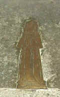
  "Some
of the oldest memorials in the church are on the floor of the
central aisle of the nave. At the the chancel end... is a small
but beautiful brass of a lady standing on a grass mound. She
wears a long, tight fitting gown edged with fur, and with fur
cuffs; an ornamental girdle, hanging centrally, broad-toed
shoes, and a pendimental head-dress with long embroidered
lappets. The character of the brass suggests an early sixteenth
century date, and there is a legend that this may be in memory
of Joan Colepeper..." "Some
of the oldest memorials in the church are on the floor of the
central aisle of the nave. At the the chancel end... is a small
but beautiful brass of a lady standing on a grass mound. She
wears a long, tight fitting gown edged with fur, and with fur
cuffs; an ornamental girdle, hanging centrally, broad-toed
shoes, and a pendimental head-dress with long embroidered
lappets. The character of the brass suggests an early sixteenth
century date, and there is a legend that this may be in memory
of Joan Colepeper..."
(Source: Pamphlet dated May 1981 from the Parish
Church of Saint John the Baptist, Crawley, Sussex.)
Any Culpeper associated with this church would most likely
have been a member of the Wakehurst line, seated nearby at
Ardingly. The only known Joan to have been in the Wakehurst line
of the Culpepers was a great-granddaughter of Nicholas and
Elizabeth Culpeper of Wakehurst. She was born circa 1533,
consistent with the sixteenth century reference in the church pamphlet.
Both photos above were taken by Warren Culpepper in
March 2000.
St. John the Baptist Location: On High Street in
Crawley
National Grid Coordinates:
TQ
268 365 |
Crawley
Modern Crawley -- an amalgamation of Three
Bridges, Ifield and old Crawley village -- is one of the
original 'new towns' that came into existence as a result of the
New Towns Act 0f 1946. It's now a large and still expanding
industrial community whose development has been encouraged by
the proximity of London's Gatwick Airport -- all a very far cry
from the crow-infested clearing in Tilgate Forest from which the
town has grown. Its name has Saxon roots -- crawe leah.
We find it spelled Crauleia in 1203, then Crawele just under 50
years later, and Crawley in 1316. (Source: Judith Glover, Sussex
Place-Names, Countryside Books, 1997, p. 61)
Location: Near Gatwick Airport, 30
miles W of Goudhurst; 35 miles SW of Maidstone.
National Grid Coordinates: TQ
290 370
1831 Topographical Dictionary:
CRAWLEY, a parish in the hundred of BUTTINGHILL, rape of LEWES,
county of SUSSEX, 9½ miles (N. by W.) from Cuckfield,
containing 334 inhabitants. The church, dedicated to St. John
the Baptist, is partly in the decorated and partly in the later
style of English architecture. |
Last Revised:
02 Jan 2015
|
|