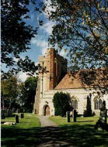
Scotsgrove Manor at Ash
Kent, England
Scotsgrove Manor
History
Scotsgrove was very anciently the estate of a family named
Torpel, and was once accounted a manor.
In the reign of
Henry V (1413-1422), Scotsgrove Manor came into the
possession of Sir Thomas Culpeper6
of Bay Hall, who willed it to his son Nicholas7,
who gave it to his daughter Joyce Culpeper8. Joyce carried
it into marriage to Walter Lewknor of Warbleton in Sussex.
At the time of the marriage, the manor was "held of Sir
Edward Poynings as of his manor of Ash, by knights service."
There was once a chapel belonging to this
estate, the foundations of which are still visible in a wood,
called Chapel-wood, in this parish; where there are other
foundations of buildings near it, and a well now covered over.
(Hasted Volume II, pages 469-471).
Location
The location of Chapel Wood, the site of the old Scotsgrove
Manor, is on the north side of New Ash Green, near the
intersection and north of Chapel Wood Road and west of Ash Road.
National Grid Coordinates: TQ
602 662
Dates, Ownership
(Monarch)
 | Circa 1420-1429: Sir Thomas Culpeper6 of
Bayhall, Hardreshull and Exton
(Henry VI) |
 | 1429-1434: Nicholas Culpeper7
(Henry VI) |
 | 1434-circa 1460: Joyce Culpeper8 and her
husband Walter Lewknor |
|
Village of Ash
Location: 20
miles NW of Goudhurst and 12 miles NW of Maidstone.
National Grid Coordinates: TQ 602 644
1831
Topographical Dictionary
ASH, a parish in the hundred of AXTON, DARTFORD
and WILMINGTON, lathe of SUTTON at HONE, county of KENT, 3¾ miles
(N by W) from Wrotham, containing 505 inhabitants. The church is dedicated to St. Peter and St. Paul. |
 Church
of St. Peter and St. Paul Church
of St. Peter and St. Paul
Ancient Parish
The Parish
Registers begin in 1560.
Research is needed to see if there was any Culpeper or Lewknor
presence in this parish.
National Grid Coordinates: TQ
603 646 |
Last Revised:
02 Jan 2015
|
|