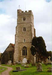
Rainham, Kent, England
Queenscourt Manor
The manor of Queenscourt, with the farm called Berengrave, was part
of the possessions of the crown and continued so until Queen Alianore,
widow of Henry III gace them in 1273 to St. Katherine's hospital. It
escaped the general suppression of such foundations by Henry VIII. Lady Sackville was lessee of
Queenscourt Manor in 1653, and afterwards, Sir Richard
Culpeper15p of Preston Hall, 2nd Bart.
Source: Hasted, History of Kent, Vol. VI,
pages 10-11.
Location: At North end of Berensgrave Lane, at the B2004?
Further research is needed.
National Grid Coordinates: TQ
821 673? |
 St.
Margaret's Church, Rainham St.
Margaret's Church, Rainham
The parish church of St. Margaret in Rainham, once a separate
village but now incorporated into Gillingham, dates mainly from the
14th and 15th centuries, but there is also some interesting Norman
work visible. Inside are some interesting murals as well as the
remains of six consecration crosses.
Source: Sean Connolly, Ed.,"Wrotham", The
Hidden Places of Kent, Travel Publishing, Ltd., 1998., pages 13.
Culpepper involvement in this church, if any, is unknown. Further
research is needed.
Location: At the intersection of th A2 and the B2004
National Grid Coordinates: TQ
817 658 |
Rainham, Kent
1831 Topographical Dictionary
RAINHAM, a parish in the hundred of MILTON, lathe of SCRAY, county
of KENT, 4 miles (E.S.E.) from Chatham, containing 1030
inhabitants. The church,
dedicated to St. Margaret, is in the early style of English
architecture: it has a lofty beacon tower, and contains several
costly monuments to the Tuftons, Earls of Thanet. The parish is
bounded on the north by the Medway; and the village, situated on
the great London and Dover road, contained, in the reign of
Elizabeth, eight houses, and there were then three quays, with
thirteen small vessels, the largest not exceeding thirty-five
tons, belonging to the place. Cherries and apples formerly
abounded here, but at present they are not cultivated to any great
extent.
Location: 8 miles NNE of Maidstone and 20 miles NNE of
Goudhurst
National Grid Coordinates: TQ
813 657 |
Last Revised:
02 Jan 2015
|
|