East
Barming
Barming is a predominately
residential area that has been subsumed into Maidstone and
so bears little resemblance to the original village.
However, it does possess a lovely wooden bridge over the
Medway, which provides a starting point for a choice of
riverside walks. One such walk goes to East Farleigh,
hugging the river bank while steep hills rise to the south.
(Hidden Places of Kent)
1831 Topographical Dictionary:
BARMING, a parish in the hundred of MAIDSTONE, lathe of
AYLESFORD, county of KENT, 2˝ miles SW from
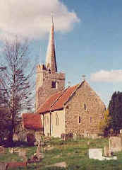
Maidstone, containing 406 inhabitants. The church, which has a fine spire, is dedicated
to St. Margaret. The river Medway, over which, at St.
Helen's, there is a timber bridge, runs through the parish.
The soil in the neighborhood is peculiarly adapted for the
cultivation of hops, and a large quantity of fruit is sent
to the London markets.
Commentary on
the 1831 Topographical Dictionary Entry
By D. A. H. Cleggett, Historical Adviser and Archivist, Leeds Castle
Foundation, 28 Aug 2000:
Events have moved since the publication
of the 1831 Topographical Dictionary. There is not a wooden
bridge over the Medway at St. Helen's. The river is spanned
by a utilitarian metal footbridge. Hops are not now grown in
any quantity in this or any other parish in Kent.
East Barming Location:
On the A-26, 2 miles W of Maidstone, 10 miles N of Goudhurst.
National Grid Coordinates: TQ
725 545


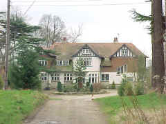 Hall Place